Richford - located between Ellerslie Road SW and 5 Avenue SW, east of 111 Street SW
Bylaw 21135 (August 29, 2025)
To allow for varying scales of mixed use development that enables the growth and development anticipated in the Nodes and Corridors as directed by statutory plans. This Zone allows for a range of Uses and supports housing, recreation, commerce, and employment opportunities. Site and building design in this Zone promotes development that enhances the public realm and publicly accessible amenities to create vibrant, walkable destinations at a scale inviting to pedestrians.
This Zone must apply to Lot 22, Block 2, Plan 2146TR, located between Ellerslie Road SW and 5 Avenue SW, east of 111 Street SW as shown on Schedule “A” of the Charter Bylaw adopting this Zone, Richford.
| 3.1. | For the purpose of this Direct Control Zone, the following General Definitions apply: | ||
| 3.1.1. | “Street” means the private road identified as the Village Connection on the map as shown in Appendix 1 and any public roadway other than an Alley and includes boulevards, sidewalks, and street furniture. | ||
| 3.1.2. | “Setback” means the distance that a development, or a specified portion of a development, must be from: | ||
| 3.1.2.1. | a Lot line; or | ||
| 3.1.2.2. | where adjacent to the private road identified as the Village Connection as shown in Appendix 1, the back of curb. | ||
| A Setback is not a Yard. A Setback only applies to development on or above ground level. | |||
| Residential Uses | |
| 4.1. | Home Based Business |
| 4.2. | Residential |
| Commercial Uses | |
| 4.3. | Food and Drink Service |
| 4.4. | Health Service |
| 4.5. | Indoor Sales and Service |
| 4.6. | Minor Indoor Entertainment |
| 4.7. | Office |
| 4.8. | Residential Sales Centre |
| Community Uses | |
| 4.9. | Child Care Service |
| 4.10. | Community Service |
| 4.11. | Library |
| 4.12. | Park |
| 4.13. | Special Event |
| Agricultural Uses | |
| 4.14. | Urban Agriculture |
| Sign Uses | |
| 4.15. | Fascia Sign |
| 4.16. | Freestanding Sign |
| 4.17. | Portable Sign |
| 4.18. | Projecting Sign |
| Residential Uses | ||
| 5.1. | Home Based Business | |
| 5.2. | Residential, limited to: | |
| 5.2.1. | Lodging House | |
| 5.2.2. | Multi-unit Housing | |
| 5.2.3. | Row Housing | |
| 5.2.4. | Secondary Suites | |
| 5.2.5. | Supportive Housing | |
| Commercial Uses | ||
| 5.3. | Bar | |
| 5.4. | Cannabis Retail Store | |
| 5.5. | Custom Manufacturing | |
| 5.6. | Food and Drink Service | |
| 5.7. | Health Service | |
| 5.8. | Hotel | |
| 5.9. | Indoor Sales and Service | |
| 5.10. | Liquor Store | |
| 5.11. | Major Indoor Entertainment | |
| 5.12. | Minor Indoor Entertainment | |
| 5.13. | Office | |
| 5.14. | Outdoor Sales and Service | |
| 5.15. | Residential Sales Centre | |
| 5.16. | Vehicle Support Service | |
| Industrial Uses | ||
| 5.17. | Indoor Self Storage | |
| Community Uses | ||
| 5.18. | Child Care Service | |
| 5.19. | Community Service | |
| 5.20. | Library | |
| 5.21. | Park | |
| 5.22. | School | |
| 5.23. | Special Event | |
| Basic Service Uses | ||
| 5.24. | Emergency Service | |
| 5.25. | Health Care Facility | |
| 5.26. | Minor Utility | |
| 5.27. | Recycling Drop-off Centre | |
| 5.28. | Transit Facility | |
| Agricultural Uses | ||
| 5.29. | Urban Agriculture | |
| Sign Uses | ||
| 5.30. | Fascia Sign | |
| 5.31. | Freestanding Sign | |
| 5.32. | Major Digital Sign | |
| 5.33. | Minor Digital Sign | |
| 5.34. | Portable Sign | |
| 5.35. | Projecting Sign | |
| Residential Uses | ||
| 6.1. | Residential | |
| 6.1.1. | Row Housing is only permitted where developed on the same Site as Multi-unit Housing or non-Residential Uses. | |
| 6.1.2. | No more than 70% of the total building Frontage facing the Village Connection as shown on Appendix 1 may contain Ground Floor Residential Uses. | |
| Commercial Uses | ||
| 6.2. | Custom Manufacturing | |
| 6.2.1. | The maximum Floor Area is 600 m2 per individual establishment. | |
| 6.2.2. | Manufacturing activities and storage must be located within an enclosed building. | |
| 6.3. | Hotels | |
| 6.3.1. | Ground Floor guest rooms must not be located adjacent to a Street. | |
| 6.4. | Major Indoor Entertainment | |
| 6.4.1. | The maximum Floor Area is 500 m2 per individual establishment, except where located on a Site greater than 1 ha. | |
| 6.5. | Outdoor Sales and Service | |
| 6.5.1. | Outdoor Sales and Service must be limited to facilities that provide pet care services. | |
| 6.5.2. | Outdoor Sales and Service uses are only permitted as an Accessory Use to an Indoor Sales and Service Use. | |
| 6.6. | Residential Sales Centres may be approved for a maximum of 5 years. | |
| 6.7. | Vehicle Support Services and Uses with Drive-through Services | |
| 6.7.1. | Drive-through Services must not be located between a building and a Street. | |
| 6.7.2. | Fencing, Landscaping, building placement or other similar measures must be provided to screen and soften the impact of Vehicle Support Services and Uses with Drive-through Services on adjacent development, Pathways, sidewalks and Streets, to the satisfaction of the Development Planner. | |
| 6.7.3. | Despite Subsection 1 of Section 6.110 of the Zoning Bylaw Vehicle Support Services must only be located in the area as shown on Appendix 1. | |
| Industrial Uses | ||
| 6.8. | Indoor Self Storage | |
| 6.8.1. | Must not be developed as a standalone building. | |
| 6.8.2. | Must incorporate windows at regular intervals on all Storeys on Facades facing Abutting Streets. Windows must be clear, transparent and non-reflective. | |
| Basic Service Uses | ||
| 6.9. | Basic Service Uses must be on a Site with at least 1 additional Use other than a Sign Use. | |
| 6.10. | Health Care Facilities | |
| 6.10.1. | The maximum Floor Area is 1,000 m2 per individual establishment. | |
| 6.11. | Recycling Drop-off Centres | |
| 6.11.1. | The maximum total area for a Recycling Drop-off Centre on a Site is 300 m2. | |
| 6.11.2. | Recycling bins and associated drive aisles and queuing lanes must not be located between a building and a Street. | |
| 6.11.3. | Perimeter screening using Fences, Landscape Buffers, or other similar features, must be provided to screen the view of drop-off areas and bins from Abutting Streets and Sites in non-industrial Zones. | |
| 6.12. | Transit Facilities | |
| 6.12.1. | Despite the Setbacks specified in Table 8.4, Transit Facilities may project into a Setback Abutting a Street to integrate with transit infrastructure in the road right- of-way. | |
| Agricultural Uses | ||
| 6.13. | Urban Agriculture | |
| 6.13.1. | The maximum Floor Area is 600 m2 per individual establishment. | |
| 6.13.2. | With the exception of outdoor display areas of products for sale, Urban Agriculture Uses must be located within or on a building. | |
| Sign Uses | ||
| 6.14. | Signs must comply with Subsections 3 and 5 of Section 6.90. | |
| Uses with Total Area and Floor Area Exceptions | ||
| 6.15. | The Development Planner may increase the maximum total area or Floor Area up to 10% for a non-Residential Use if at least one of the mitigation measures below are used to reduce negative impacts to Abutting Uses or Sites: | |
| 6.15.1. | measures specified in Subsection 2 of Section 5.120 of the Zoning Bylaw; | |
| 6.15.2. | modification of Site plans to locate Uses or activities in a location to minimize visual, noise, lighting, odour or other similar Nuisances; or | |
| 6.15.3. | other similar measures. | |
| 7.1. | “Area A" as shown in Appendix 1 must comply with the regulations in the RM - Medium Scale Residential Zone, except that: | ||||||||||||||||||||||
| 7.1.1. | The maximum Height is 28.0 m. | ||||||||||||||||||||||
| 7.1.2. | The maximum Floor Area Ratio is 3.8. | ||||||||||||||||||||||
| 7.1.3. | The minimum Density is 90 Dwellings/ha. | ||||||||||||||||||||||
| 7.1.4. | Development must comply with Table 7.1.4.: | ||||||||||||||||||||||
| |||||||||||||||||||||||
| 7.2. | Sidewalks, Pathways, and shared Pathways are permitted within a Setback along the Village Connection. | ||||||||||||||||||||||
| 7.3. | The private road identified as the Village Connection on the map as shown in Appendix 1 must include a minimum 3.0 m wide shared Pathway on the east side, and a minimum 1.8 m wide Pathway on the west side. | ||||||||||||||||||||||
| 8.1. | Development must comply with Table 8.1: | |||||||||||||||||||||||||||||||||||||||||
| ||||||||||||||||||||||||||||||||||||||||||
| 8.2. | Floor Area associated with Residential Uses is excluded from the calculation of the maximum Floor Area Ratio where a minimum of 10% of all Dwellings: | |||||||||||||||||||||||||||||||||||||||||
| 8.2.1. | comply with the inclusive design requirements of Section 5.50; | |||||||||||||||||||||||||||||||||||||||||
| 8.2.2. | have a Floor Area greater than 100 m2, a minimum of 3 bedrooms, are located below the 8th Storey of the building, and have: | |||||||||||||||||||||||||||||||||||||||||
| 8.2.2.1. | access to an outdoor Common Amenity Area designed for children of at least 50.0 m2; and | |||||||||||||||||||||||||||||||||||||||||
| 8.2.2.2. | dedicated and enhanced bulk storage within the Dwelling or within the building. | |||||||||||||||||||||||||||||||||||||||||
| 8.3. | The maximum Floor Area Ratio is increased by 1.0 where: | |||||||||||||||||||||||||||||||||||||||||
| 8.3.1. | a minimum of 40% of all Supportive Housing Sleeping Units comply with the inclusive design requirements of Section 5.50; or | |||||||||||||||||||||||||||||||||||||||||
| 8.3.2. | 1 or more buildings listed in the Inventory of Historic Resources is maintained as part of a proposed development to the satisfaction of the Development Planner, in consultation with the City department responsible for heritage planning. | |||||||||||||||||||||||||||||||||||||||||
| 8.4. | Development must comply with Table 8.4: | |||||||||||||||||||||||||||||||||||||||||
| ||||||||||||||||||||||||||||||||||||||||||
| 8.5. | Development must comply with Table 8.5: | |||||||||||||||||||||||||||||||||||||||||
| ||||||||||||||||||||||||||||||||||||||||||
| 8.6. | Sidewalks, Pathways, and shared Pathways are permitted within a Setback along the Village Connection. | |||||||||||||||||||||||||||||||||||||||||
| 8.7. | The private road identified as the Village Connection on the map as shown in Appendix 1 must include a minimum 3.0 m wide shared Pathway on the east side. | |||||||||||||||||||||||||||||||||||||||||
| Building Design Regulations | ||
| 9.1. | Where a building wall: | |
| 9.1.1. | faces a Street or Park; | |
| 9.1.2. | has a main entrance facing a Public Amenity Area or Parking Area interior to the Site; or | |
| 9.1.3. | has a total length greater than 20.0 m facing a Site in a residential or mixed use Zone, the Facade must be articulated using 2 or more design techniques or features to minimize the perception of massing, eliminate large blank walls, provide visual interest, and enhance the appearance of buildings during winter months. Design techniques or features may include: variations in rooflines; vertical or horizontal building wall projections or recessions; visual breaks of building Facades into smaller sections; use of a combination of finishing materials; or other similar techniques or features. | |
| 9.2. | Subsection 9.1 does not apply to: | |
| 9.2.1. | building walls facing and built to a shared Lot line to establish a continuous Street Wall with the Abutting Site. | |
| 9.3. | Ground Floor non-Residential Facades facing Streets, and any Facade with a main entrance that faces a Parking Area, must be designed to break up the appearance into sections of 11.0 m or less by incorporating 2 or more design features such as those described in Subsection 9.1. | |
| 9.4. | Each Storey must have windows on all building Facades facing a Street. | |
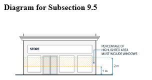
| 9.5. | To promote pedestrian interaction and safety, Ground Floor non-Residential Facades must comply with the following: | |
| 9.5.1. | Where a Facade faces Ellerslie Road SW, a minimum of 30% of the Facade area between 1.0 m and 2.0 m above ground level must be windows. | |
| 9.5.2. | Where a Facade faces the private road identified as the Village Connection on the map as shown in Appendix 1, a minimum of 65% of the Facade area between 1.0 m and 2.0 m above ground level must be windows. | |
| 9.5.3. | A maximum of 10% of all Ground Floor windows facing a Street, a Parking Area or along Facades with a main entrance facing a Public Amenity Area or Parking Area interior to the Site may be covered by non-transparent material. The remainder must be clear, non-reflective and free from obstruction. | |
| ||
| 9.6. | The Facade design and materials must wrap around the side of the building to provide a consistent profile facing both Streets at the intersection of Ellerslie Road SW and the private road identified as the Village Connection on the map as shown in Appendix 1. | |
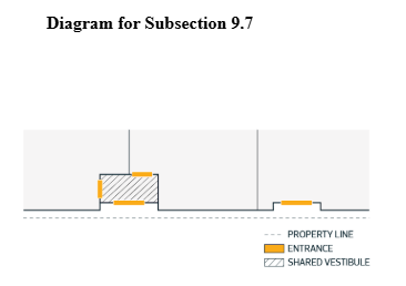
| Entrance Design Regulations | ||
| 9.7. | Where non-Residential Uses are located on the Ground Floor, separate individual entrances must be provided, but may share a common vestibule. | |
| ||
| 9.8. | Where buildings are located adjacent to the east side of the Village Connection as shown on Appendix 1, the main entrances for these buildings must: | |
| 9.8.1. | face the Village Connection; and | |
| 9.8.2. | be level with, or have sloped doorway thresholds to, Abutting Pathways and public sidewalks. | |
| 9.9. | Dwelling units with at-grade entrances must provide a semi-private space to act as a transition area from Streets. This can be established through the use of features such as fencing, Landscaping, porches, or other similar measures. | |
| 9.10. | Main entrances must incorporate weather protection features in the form of canopies, awnings, overhangs, vestibules, recessed entrances, or other Architectural Elements to provide all-season weather protection to pedestrians and to enhance the visibility of entrances. | |
| Parking, Loading, Storage and Access | ||
| 10.1. | Vehicle access to Ellerslie Road SW must be located in accordance with Appendix 1 and designed to the satisfaction of the Development Planner in consultation with the City department responsible for transportation planning and at the Development Permit stage. | |
| 10.2. | Surface Parking Lots east of the Village Connection, as shown on Appendix 1, must be located to the rear or sides of the principal building or interior to the Site. | |
| 10.2.1. | Surface Parking Lots must not occupy more than 10% of the total linear distance measured along the Frontage Border facing Ellerslie Road SW and the Village Connection, as shown in Appendix 1. | |
| 10.3. | Despite the Setbacks specified in Table 8.4 and 8.5: | |
| 10.3.1. | Loading, storage, and waste collection areas must not be located between a principal building and a Street and must provide a minimum 3.0 m wide Landscape Buffer where adjacent to a Street. | |
| 10.3.2. | Surface Parking Lots and loading, storage, and waste collection areas may project into, or be located within, a Setback Abutting another Site where a minimum 1.5 m wide Landscape Buffer is provided within the Setback. | |
| 10.4. | Above-ground Parkade Facades facing a Street or a Park must be wrapped with Commercial or Community Uses, with a minimum depth of 8.0 m, on the Ground Floor. | |
| 10.5. | Above-ground Parkades must be designed to be adaptable for future non-parking Uses by having: | |
| 10.5.1. | a minimum floor to ceiling clearance of 4.0 m at ground level, and 3.1 m above the Ground Floor; | |
| 10.5.2. | floors that can readily become level; and | |
| 10.5.3. | drive ramps located and designed to allow for future removal without interfering with developable space. | |
| Other Regulations | ||
| 10.6. | Despite the Setbacks specified in Table 8.4, outdoor display areas and Public Space may be located in a Setback Abutting a Street. | |
| 10.7. | Pathways, shared Pathways, and pedestrian crossings must be provided as per Appendix 1. | |
| 10.7.1. | Pedestrian crossing must be at a safe location for pedestrians to cross the Village Connection and must include pavement markings and crossing signs. Additional safe crossing elements, such as raised crosswalks or curb extensions, may be required, and must be implemented to the satisfaction of the Development Planner in consultation with the City department responsible for transportation planning and traffic operations. | |
| 10.8. | Pathways, shared Pathways, and the Village Connector must be accessible to the public at all times through the registration of a 24-hour Public Access Easement in favour of the City of Edmonton, which must be a condition of the development permit for the first building on the site. Under this Easement, the owner is responsible for maintenance and liability and the spaces must be accessible to the public at all times. | |
| 10.9. | Traffic calming design features to improve safety and discourage shortcutting must be incorporated into the designs of 6 Avenue SW and the Village Connection. Design features may include, but are not limited to, speed bumps, raised crosswalks, speed displays, curb extensions, signage, or pavement marking. Such design features must be implemented to the satisfaction of the Development Planner in consultation with the City department responsible for transportation planning and traffic operations. | |
| 11.1. | As a condition of any Development Permit, the Owner must enter into an Agreement with the City of Edmonton for off-Site improvements necessary to serve the development to the satisfaction of the Development Planner in consultation with the City department responsible for transportation planning and traffic operations. Such improvements must be constructed at the Owner’s cost. The agreement process must include an engineering drawing review and approval process. Improvements to be addressed in the Agreement include but are not limited to: | |
| 11.1.1. | The construction of 6 Avenue SW to a collector roadway standard, with a shared pathway on the south side, between 111 Street SW and the existing 6 Avenue SW, with appropriate transitions to the existing 6 Avenue SW. | |
| 11.1.2. | Construction of the intersection at 6 Avenue SW and the Village Connection, including stop control on all approaches, and traffic calming measures such as curb extensions and raised crosswalks. | |
| 11.1.3. | Installation of a northbound right-turn bay, eastbound left turn and shared through/right turn lane, westbound left turn and shared through/right turn lane, and traffic signals at the intersection of 111 Street SW and 6 Avenue SW. The timing of the signal installation will be at the direction of the City department responsible for Traffic Operations. If appropriate road width is available, the eastbound and westbound lanes may be delineated by pavement markings only. | |
| 11.1.4. | Converting the intersection at Ellerslie Road SW and the Village Connection to a right-in/right-out/left-in configuration for the north and south approaches, including any required modifications to the concrete centre median and construction of a westbound right-turn bay / auxiliary lane. | |
| 11.1.5. | Removal of the existing sidewalk and construction of a minimum 3.0 m wide shared pathway in its place along the north side of Ellerslie Road SW between 109 Street SW and 111 Street SW. | |